“Drones are changing the game in the communications tower industry from a safety, quality and efficiency perspective.” – Jacob Cowart
The increased number of aerial cell tower inspections completed using drones in the past years, present the communication industry with opportunities and challenges alike.
Cell tower inspections.
Tower owners are facing the need to inspect their assets more frequently, as the assets age and the industry grows rapidly. Inspecting towers frequently lets owners avoid minor maintenance issues becoming giant, costly headaches.
Inspections are also required when assessing tower condition prior to a purchase or transaction, and upon a new build, a retrofit, or a colocation. The latter inspection types are meant to verify that the construction is in accordance with industry standards and project specifications alike.
Cell tower inspections can be worth gold.
One wireless company in the U.S owns more than 65,000 cellular towers alone and many companies lease physical spaces on their towers to third parties. This creates bountiful opportunities for DSPs wanting to fly not only the wireless company’s towers but also the leased spaces for other clients, all in one tower inspection.
Cell towers are plentiful and come in a wide variety of types, each of which comes with different methodologies and levels of complexity. We have summed up the most common below.
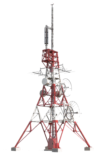
Self-Support Tower
Constructed with 3 or 4 legged lattice-type structures offer the most possibilities compared to other types of telecom towers. These can support the heaviest load and withstand strong winds and weather conditions.

Lattice Tower
Freestanding with rectangular or triangular base steel lattices. These are typical for mounting a large number of dish or panel antenna.
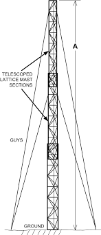
Guyed Tower
A slender steel structures that are supported by level(s) of braided or stranded steel guy cables that anchor to the ground. These efficient and versatile towers are capable of maximum strength with a relatively easy installation.

Monopole Tower
A single-pole that can be a tubular or tapered pole are the most popular because it reduces visual impact, the low cost and speed of installation.
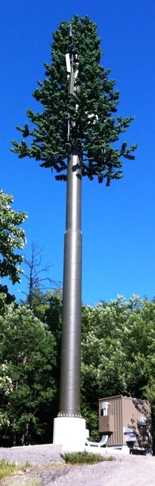
Camouflage Tower
May be designed to appear as an artificial pine tree, palm tree, clock tower, or even an artificial cactus, in order to blend in and reduce visual impact in the community.
Immense opportunities
There are many types of cell tower inspections. The standard visual inspection can be combined with additional services that can maximize the value of the inspection:
- Pre / Post Tower Construction
- Periodic Tower Structural Audit Inspections – Visual
- Periodic Cellular hardware Inspections – Visual/Thermal
- Asset Location Mapping/3D Modeling – Ortho Photogrammetry
- LiDAR – for Point Cloud, Geo-Tagging
- RF (Radio Frequency) Inspections
So, like the so boldly states, the opportunities are immense – especially for the tower owners who need to know the ongoing condition of the asset in order to provide the best customer experience to their millions of wireless consumers.
The service provider can be an essential and valued extension to the Wireless Carrier by providing world-class inspection data and analytics for the tower owners.
and challenges.
Historically, performing cell tower inspections, required heavy equipment that needed to be transported to the tower location. There was also a real safety concern for the team of people physically climbing the structure. It required not only qualified technical skills to perform the inspection; (i.e. an understanding of structural integrity, along with technical knowledge to inspect the Cellular components) but also a team of experienced climbers.
The rise of Autonomous Drones brought cell tower inspections into the 21st century, and eliminated most of those challenges, all in one move.
Service providers are now utilizing these innovative methods, performing inspections safely from the ground, much faster, and with little to no educational background.
The CBA (cost-benefit analysis) ratio of cell tower inspections has drastically improved along with the quality of the data and the frequency of the data acquisition.
But, while drones have the potential to eliminate costly and hazardous man-hours, it also presents a new challenge: effectively managing the large amounts of data, that drones capture.
Best cell tower inspection drone.
While it is impossible to say that one drone is the “best cell tower inspection drone”, we can break down some of the elements that make a drone suitable for cell tower inspections and give a few examples of such drones.
Consider the flight-time when looking for the right drone for your tower inspection. You want one that can easily do ground to tower-top and back again – ideally twice, as you might have to go back up and re-inspect faulty items.
Stability is also important to consider, when inspecting cell towers with a drone. Working in the heights that many towers reach means you are dealing with heavy winds, even on the best of days, and your equipment must be able to handle that.
You will also have to look at payload. Images should be clear, even in shaky conditions, and some of the cameras that the lower price-range drones are delivered with, simply won’t cut it. There is of course always the option to upgrade your payload, in which case you could consider something like DJI’s ZenMuse Z30 which is designed specifically for tower inspections.
Your last consideration is budget. There are great options at every budget, but the lower price-range drones do come with compromises. Consider your budget and other needs, before deciding on the right model for you.
Here are a few drones that are often mentioned as specifically good for cell tower inspections:
Also, no matter what you’re flying, make sure you keep a safe distance from the tower to avoid electromagnetic interference during your cell tower inspection with a drone.
Drone cell tower inspection training.
If you have never flown cell towers before, it can be a good idea to do a class prior to your first job. Because of their height and the many regulations surrounding cell towers, there are many things to keep in mind when your surveying them with a drone.
Examples of courses that offer drone cell tower inspection training are this course from NATE or this one from Technical Rescue Systems which leaves you with a certification and is (for the time being) carried out virtually.
If you’re not ready to invest in a course or certification, this article from the Drone Pilot School sums up the most important things to keep in mind when surveying towers, and even includes a nice little flight guide, so be sure to check it out.
Managing large amounts of drone data.
The communication industry is one of the first industries to greatly benefit from the use of drones and UAVs.
But with the rise of commercial drones, comes the need for proper data management. To truly scale up the operations of drones to a commercial grade, the industry must improve their data management procedures, or they will fail to harvest the many benefits of this new inspection method.
Using drone inspection management software to detect damages and flaws in cell towers, is extremely efficient compared to using traditional methods of inspection image analysis.
Benefits of image processing software
- Processing images in efficient software saves time and money.
- A higher degree of detail in images and digital annotation of faults makes it easy to decide on rectifying actions.
- Pin-pointing the exact location of defaults is easy using geo-tagging, and saves repair-crews time and trouble.
- Sharing information with relevant stakeholders is effortless through customizable reports, sending single images or by granting outside stakeholders with access to the system.
- Images are always safely and securely stored.
- For inexperienced DSP’s, having access to Scopito’s expert analysis means you can offer a more complete product to the end client.
The best software for processing Cell Tower inspections; Scopito.
Considering trying Scopito yourself?
The first 14 days are free and there is no commitment.
How much to charge for cell tower inspections?
Once you’ve understood the immense possibilities of cell tower inspections, found the right drone, completed the necessary training and acquired good processing and reporting software, it’s time to consider how much you are going to charge for your cell tower inspection services.
We get asked this all the time, daily even: “how much do I charge for cell tower inspections?”. The answer is always; that depends.
So what does the amount you can charge depend on? Let’s break it down.
There are a large number of factors to consider, when pricing your inspection services. The three most important being:
1. Your level of expertise
2. The market you are selling in
3. Your costs
How much to charge for cell tower inspections; a formula.
When you are deciding on a price for a certain inspection, it can be very helpful to work from the ‘Costs + Markup’-model. You calculate your costs, and depending on the market and your level of expertise, you add a percentage markup to that price, which will then be your revenue.
Having an excel-sheet to fill in, is a great way of calculating how much to charge for cell tower inspections (or other types of inspections).
Now let’s look at this step by step:
1. Estimating costs
Depending on the type of job you’re flying, it makes sense to estimate your costs on a per day, per mile or per asset inspected. For cell tower inspections, estimating costs per asset is the obvious choice in most situations.
The following are costs that would often be involved in a cell tower inspection job:
- Insurance
- Travel expenses
Flights, accommodation, food. Depending on the job site’s location, these can vary for you. - Equipment
Are you doing a simple KML inspection, or adding thermal images, LiDAR, or something else? You will need different kinds of equipment depending on the type of inspection, so factor this into your costs. - Software
What will your deliverables look like? Are you responsible for reporting, data storage, 3D models, analysis? If so, your software costs have to be factored in as well.
Services you, as a DSP, will typically need to consider for cell tower inspections are:
– Visual/RGB inspection
– Thermal inspection
– RF testing (more common for radio/television towers)
– Ortho/Photogrammetry
– LiDAR
– Analytics & reporting
2. Adding a markup
This is where things like your level of experience, the number of people you need on the job, and the market you are operating in, come into play.
In some markets, for example, charging a 50% markup is absolutely fine, while in others, 10% is more reasonable.
When deciding on a percentage, consider:
- How much time you will be spending on the flight
Your time is a valuable resource, and the price should go up with your level of expertise, as flight time will decrease and results will get better. - How much time you will be spending on image analysis
If you are responsible for this task, consider how much time you will be using. If you are outsourcing, add the price to your costs. - What the general price levels in your country/area are
Depending on the value of a certain currency, 50% can be very thin margins or 20% can be a lot. This is the major consideration you should be doing when pricing your services. - The size and budget of your client
What you are able to charge also depends on your client’s size and budget. The bigger the budget, the larger the markup – for the most part.
Add all of these to your spreadsheet, and you will have a good answer for how much to charge for cell tower inspections.
Upgrades to infrastructure and maintenance
Inspection reports are currently used by companies to compare performances pre- and post installations or repairs. A mal-positioned antenna has a devastating impact on signal-reach and efficiency.
Scopito reports enable engineers to get an updated view and troubleshoot a variety of errors, long before reaching the site.
Users can look up custom made sub-sets of images (with custom-made tags), to accommodate their focus. Images can be categorized as ‘Verified as a problem’, ‘Point of interest’, ‘Colour coded mounts’ or any custom annotations, making it easy to group the images.
Preserving nature
An American Scopito user successfully minimized the impact of cell towers on nature by using Scopito.
Local law prohibits carriers from doing any type of work or upgrades to a site that is inhabited by nests of endangered spices, like the Osprey.
By using the custom defined tags, they were able to filter historical data and learn on the traffic in the nests. Visual verification allows for an environmental biologist to speed up the process and share reports quickly with stakeholders.
Overcoming great distances
The vastness of the telecommunication coverage makes it necessary for companies to work with multiple contractors, inspectors or technicians.
Successfully facilitating this process by allowing users to create a private view for each one of their customers, is the main focus of the Scopito software.
Each one of the stakeholders in the process is provided with private login and a focused view of the inspections relevant to them. This enables multiple contributors to collaborate as well as work independently.
Utilizing layered maps
The ability to layer maps can drastically increase the value of inspection data, as images are presented over custom up-to-date maps, imported from other services. Engineers and technicians are able to plan upgrades to maps imported from map services such as DroneDeploy and use this to evaluate the impact of seasonal changes on the site.
The proper data management software will reduce costs, promote positive customer interactions and above all handle your data in a secure way and with a high degree of usability.
In Conclusion
After reading this article, we hope that we have provided clarity and knowledge to the potential challenges and the absolute opportunity to engage proper inspection solutions.
We at Scopito understand the financial and (no less important) social impact that Wireless Carriers face if there are any interruptions to your services. We are always happy and ready to offer our expertise and assist you with your inspection strategy.
Reach out today for a talk about your opportunities.


